Nearby Villages
(click on symbol to see the village page) |
| Village= | |
Town= | |
Recorded in Domesday= |  |
|
|
|
|
Ashburnham |
(Last Iron Furnace in Sussex) | | 2.21 miles |
|
|
Battle |
(William the Conqueror prevails) | | 6.19 miles |
|
|
Boreham Street |
(Picturesque village on top of the Ridge) | | 2.78 miles |
|
|
Brightling |
(famous for Mad Jack Fuller) | | 4.27 miles |
|
|
Cade Street |
(Jack Cade and the Kentish rebellion) | | 4.47 miles |
|
|
Catsfield |
(Iron, Railways and Clocks) | | 4.89 miles |
|
|
Chiddingly |
(Walking on Cheese ??) | | 6.47 miles |
|
|
Dallington |
(Custers Last Stand!) | | 2.39 miles |
|
|
Hailsham |
(Ropes and Napoleon) | | 5.14 miles |
|
|
Heathfield |
(19th Century Natural Gas) | | 5.26 miles |
|
|
Hellingly |
(Only remaining Ciric in Sussex) | | 4.54 miles |
|
|
Herstmonceux |
(Castle and Observatory) | | 1.93 miles |
|
|
Hooe |
(The Haunt of Smugglers) | | 4.12 miles |
|
|
Horam |
(Which Station do we get off at ?) | | 4.56 miles |
|
|
Mountfield |
(17th Century Coal !!) | | 6.70 miles |
|
|
Netherfield |
(Village at the top of the Hill) | | 4.41 miles |
|
|
Ninfield |
(Last of the Iron Stocks) | | 4.14 miles |
|
|
Penhurst |
(Beautiful yet Remote) | | 2.99 miles |
|
|
Punnetts Town |
(The Windmill on the Hill) | | 3.36 miles |
|
|
Rushlake Green |
(Open Village and Nuclear Bunker) | | 2.32 miles |
|
|
Vines Cross |
(Cannons and Doodlebugs) | | 3.71 miles |
|
|
Waldron |
(Fullers Earth) | | 6.61 miles |
|
|
Warbleton |
(The Iron Man) | | 3.02 miles |
|
|
Wartling |
(World War II defence centre) | | 3.77 miles |
|
|
Windmill Hill |
(Largest Post Mill in Sussex) | | 2.00 miles |


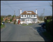 Bodle Street in East Sussex is a small village lying between
  The White Horse public house at
  The White Horse together with the village hall and the church
provide the only services.
The White Horse together with the village hall and the church
provide the only services.


